Pure North
Resources Inc.

We focus on the exploration, development and production of nickel and related base metals from our assets in the Shaw Dome, a highly prospective nickel belt located near Timmins, Ontario.

Company Overview

Pure North Resources Inc:
Exploring Ontario's Prospective Nickel Belt.

Pure North Resources Inc. (formerly Liberty Mines Ltd.) has historically focused on the exploration, development and production of nickel and related base metals from its assets in the Shaw Dome, a prospective nickel belt near Timmins, Ontario. The Company owns and operates the only nickel concentrator in the area. Northern Sun’s key assets include:

  • A 100% interest in 12,000 ha property located in the Shaw Dome Nickel Belt, which is 25 km southeast of Timmins.
  • The Redstone nickel mine and 1500 tpd Redstone Mill;
  • The McWatters nickel mine;
  • A 100% interest in the 6,400 ha Groves nickel copper platinum group metals (“PGM”) project, which is located 20 km southeast of Gogama, Ontario (between Timmins and Sudbury).
  • A 100% interest in the 6,200 ha McAra Lake-Ray cobalt nickel copper project, which is located about 120 km southeast of Timmins.

Company Overview

Our Projects Overview

Pure North Resources Inc. is a past producer of nickel and is focused on the exploration, development and production of primarily nickel, together with lesser amounts of copper, cobalt and platinum group metals from its properties in Ontario, Canada. It owns and operates the Redstone concentrator near Timmins Ontario.

Redstone Mine

The Redstone nickel mine, discovered in 1987, is located 24 kilometers south east of Timmins, Ontario, Canada.

Mcwatters Mine

The McWatters nickel deposit is located approximately 29 kilometers southeast of the city of Timmins, Ontario, Canada.

Hart Project

The Hart nickel deposit is located approximately 27 km southeast of the City of Timmins, Ontario, Canada.

Groves Project

The Groves nickel copper platinum group metals (“PGM”) deposit is located approximately 15 km south east of Gogama, Ontario. 

Croxall Project

Drilling conducted on the Croxall property in 2011 provided encouraging results and as a result, further work has been proposed for this property.

View More Projects

Our Equipment

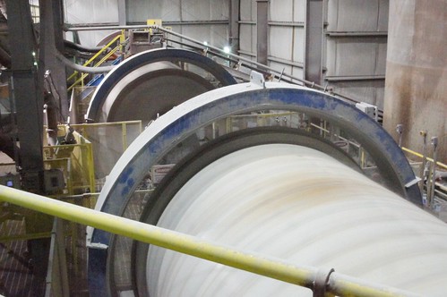
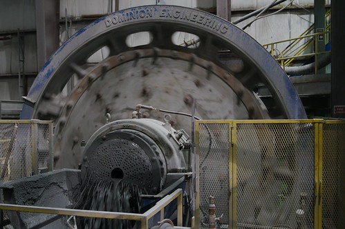
Redstone Mill Overview

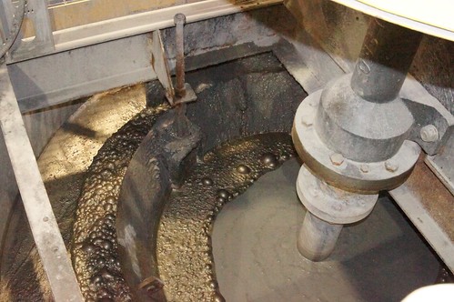
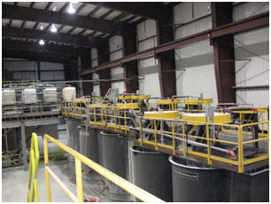
The Redstone Mill was constructed as a Nickel Concentrator in 2006/2007 to specifically handle up to 2,000 tonnes per day of altered komatiite ore. Redstone is the only mill in the Shaw Dome Nickel Belt area. Northern Sun will operate the mill on a toll mining basis in 2014-2015.

Projects

Latest News

Company News 4

orem Ipsum is simply dummy text of the printing and typesetting industry. Lorem Ipsum has been the industry’s standard dummy text ever since the 1500s, when an unknown printer took a galley of type and scrambled it to make a type specimen book. It has survived not only five centuries, but also the leap into electronic typesetting, remaining essentially unchanged. It was popularised in the 1960s with the release of Letraset sheets containing Lorem Ipsum passages, and more recently with desktop publishing software like Aldus PageMaker including versions of Lorem Ipsum. Why do we use it? It is a long established fact that a reader will be distracted by the readable content of a page when looking at its layout. The point of using Lorem Ipsum is that it has a more-or-less normal distribution of letters, as opposed to using ‘Content here, content here’, making it look like readable English. Many desktop publishing packages and web page editors now use Lorem Ipsum as their default model text, and a search for ‘lorem ipsum’ will uncover many websites still in their infancy. Various versions have evolved over the years, sometimes by accident, sometimes on purpose (injected humour and the like). Where does

Read More »

Company News 3

Lorem Ipsum is simply dummy text of the printing and typesetting industry. Lorem Ipsum has been the industry’s standard dummy text ever since the 1500s, when an unknown printer took a galley of type and scrambled it to make a type specimen book. It has survived not only five centuries, but also the leap into electronic typesetting, remaining essentially unchanged. It was popularised in the 1960s with the release of Letraset sheets containing Lorem Ipsum passages, and more recently with desktop publishing software like Aldus PageMaker including versions of Lorem Ipsum. Why do we use it? It is a long established fact that a reader will be distracted by the readable content of a page when looking at its layout. The point of using Lorem Ipsum is that it has a more-or-less normal distribution of letters, as opposed to using ‘Content here, content here’, making it look like readable English. Many desktop publishing packages and web page editors now use Lorem Ipsum as their default model text, and a search for ‘lorem ipsum’ will uncover many web sites still in their infancy. Various versions have evolved over the years, sometimes by accident, sometimes on purpose (injected humour and the like). Where

Read More »

Company News 2

Lorem Ipsum is simply dummy text of the printing and typesetting industry. Lorem Ipsum has been the industry’s standard dummy text ever since the 1500s, when an unknown printer took a galley of type and scrambled it to make a type specimen book. It has survived not only five centuries, but also the leap into electronic typesetting, remaining essentially unchanged. It was popularised in the 1960s with the release of Letraset sheets containing Lorem Ipsum passages, and more recently with desktop publishing software like Aldus PageMaker including versions of Lorem Ipsum. Why do we use it? It is a long established fact that a reader will be distracted by the readable content of a page when looking at its layout. The point of using Lorem Ipsum is that it has a more-or-less normal distribution of letters, as opposed to using ‘Content here, content here’, making it look like readable English. Many desktop publishing packages and web page editors now use Lorem Ipsum as their default model text, and a search for ‘lorem ipsum’ will uncover many web sites still in their infancy. Various versions have evolved over the years, sometimes by accident, sometimes on purpose (injected humour and the like). Where

Read More »

Company News 1

Lorem Ipsum is simply dummy text of the printing and typesetting industry. Lorem Ipsum has been the industry’s standard dummy text ever since the 1500s, when an unknown printer took a galley of type and scrambled it to make a type specimen book. It has survived not only five centuries, but also the leap into electronic typesetting, remaining essentially unchanged. It was popularised in the 1960s with the release of Letraset sheets containing Lorem Ipsum passages, and more recently with desktop publishing software like Aldus PageMaker including versions of Lorem Ipsum. Why do we use it? It is a long established fact that a reader will be distracted by the readable content of a page when looking at its layout. The point of using Lorem Ipsum is that it has a more-or-less normal distribution of letters, as opposed to using ‘Content here, content here’, making it look like readable English. Many desktop publishing packages and web page editors now use Lorem Ipsum as their default model text, and a search for ‘lorem ipsum’ will uncover many web sites still in their infancy. Various versions have evolved over the years, sometimes by accident, sometimes on purpose (injected humour and the like). Where

Read More »

Tight Team. Knows How to Find, Develop and Operate a Mine

Management

The Board currently has five committees: Audit; Compensation, Corporate Governance and Nominating, Special Opportunities and the Health, Safety and Environmental Committee of which the Audit, Compensation and Corporate Governance and Nominating and Health, Safety and Environmental Committees have mandates.

We focus on the exploration, development and production of nickel and related base metals from our assets in the Shaw Dome, a highly prospective nickel belt located near Timmins, Ontario.

Get In Touch

123 Main Street
New York, NY 10001

Redstone Mine

The Redstone nickel mine, discovered in 1987, is located 24 kilometers south east of Timmins, Ontario, Canada. Previous operators of the property mined 276,700 tonnes grading 2.4% nickel (“Ni”) from the upper 213 m of the deposit in the 1989-1996 periods.

Northern Sun dewatered the mine during the fall of 2005, and commenced production mid 2006. Shrinkage stoping was the traditional mining method used to exploit the rich veins (typically grading 14% Ni to 32% Ni) in the footwall contact of the komatiite and the underlying dacite known as the R-zone.

Re-examination of drill data from 2007-2008 and earlier historical data revealed three mineralized zones roughly parallel to the footwall R-zone (massive pyrrhotite-pentlandite mineralization that has been the main target in the mine). These zones are typical of the parallel shoots known in the Kambalda Nickel Belt of Australia, and are prime exploration targets.

The H-zone (hanging wall zone) occurs in a mineralized horizon that stratigraphically overlies the R-zone by approximately 20m. The H-zone has been drilled from the 213m and 244m levels and the following intersections and grades were obtained: UG7-12 at 11.15% Ni over 0.4m; UG8-18 at 2.52% Ni over 4.5 m; UG7-04 at 1.97% Ni over 2.95 m; UG8-29 at 4.19%Ni over 1.08 m; and R06-08 which showed 2.26% Ni over 1.85 m.

The E-zone was intersected during 2007 surface drilling in hole R07-93, which assayed 3.05 m grading 3.77% Ni (including 0.5m grading 19.03% Ni). The E-zone appears to be a secondary shoot of mineralization occurring approximately 60m east from the R-zone. It lies on the main Redstone lithological contact between komatiite and footwall dacite and appears to be a parallel zone. The contact can be traced in outcrop and by mag and EM surveys. The target remains open to the east and corresponds well to a 1.5km long EM conductor identified in earlier geophysical surveys.

The historically known S-zone is a parallel zone located stratigraphically about 60m above the R-zone. Drill hole R-41 intersected 4.0m of mineralization in the interval 113.4m to 117.4m grading 1.02 % Ni. There are 4 other historically known drill holes of similar grades which may have intersected the S-zone.

These three target zones were not included in the resource estimation stated above and provide additional potential to expand the overall resource and reserves of the Redstone mine.

RESERVES AND RESOURCES

The pre-feasibility study for the Redstone Mine was released January 11, 2010. The mineral resource estimate at a cut-off grade of 0.51% nickel (“Ni”) consists of 599,000 tonnes in the Measured and Indicated categories grading 1.47% Ni and 0.02% copper (“Cu”); and 737,000 tonnes in the Inferred category grading 1.57% Ni and 0.03% Cu. The Proven and Probable Mineral Reserves were estimated at 259,900 tonnes with an average grade of 1.04% nickel (“Ni”) using a nickel price of US$15,430 per tonne (US$7.00 per pound) and an exchange rate of $1.00 CDN = $0.90 US. There is a strong potential to increase the Inferred Resources in the lower zone between 510m and 1150m; and to upgrade the current Inferred resources to the Indicated category with additional drilling. The reserves would be positively increased and the life of mine extending accordingly.

RESTARTING PRODUCTION

At the start of the first quarter 2011, the Redstone Mine was place on care and maintenance. A detailed production plan is currently being prepared to analyze the accessibility and viability of the stopes above the 1600 metre level. The Redstone Mine continues to be dewatered in anticipation of returning to production. An exploration plan is in progress to identify the mineralization below 1600 metre level.

Further exploration and development will be deferred until long-term nickel prices improve.

Mcwatters Mine

The McWatters nickel deposit is located approximately 29 kilometers southeast of the city of Timmins, Ontario, Canada in Langmuir Township and about 9.5 km east of the Redstone Mine.

RESERVES AND RESOURCES

Nickel sulphide mineralization at the McWatters Mine occurs in two zones: the upper lower grade disseminated sulphide zone and the lower high grade massive sulphide zone.

A National Instrument 43-101 compliant resource calculation was released in October 2005. After additional definition drilling was completed in the fall of 2007, an updated NI 43-101 compliant resource was subsequently released on December 18, 2008. The technical report stated an indicated resource of 665,308 tonnes of mineralization grading 0.72% Ni in the upper zone and 49,562 tonnes grading 3.93% Ni in the lower zone with an inferred resource of 13,829 tonnes grading 3.39% Ni in the lower zone. The feasibility study of December 18, 2009 estimated the Probable Mineral Reserves at 872,000 tonnes with an average grade of 0.70% Ni using a nickel price of US$15,430 per tonne (US$7.00 per pound) and an exchange rate of $1.00 CDN = $0.90 US. The life of mine for the McWatters project was two years at an average production rate of 1800 tonnes per day.

PRODUCTION

Ramp development was completed to the 155m level in early January 2010. Cut and fill mining on the 155m level commenced firstly and commercial production was declared in January 2010. An open pit allows removal of the crown pillar with the balance of the mine exploited with sublevel caving to the 140m level. The production was stopped in February 2011 due to problems with the Redstone Mill’s tailings storage facility.

Mining was restarted in Q1 2012 after the Redstone Mill tailings pond issues were resolved. Unfortunately in August of 2012, mine production was again halted due to poor market conditions. It was the discovery of asbestos in January 2013 that has pushed the site into closure. Subsequent to this, the McWatters Mine was permanently closed with rehabilitation planned for 2014, 2015 and 2016.

Hart Project

The Hart nickel deposit is located approximately 27 km southeast of the City of Timmins, Ontario, Canada in Eldorado Township and about 6 km east of the Redstone Mine.

GEOLOGY

The ore-body is interpreted to be plunging 20 degrees to the east following a trough-like embayment flanked by sulphide-facies iron formation. This conforms with the classical Kamblada-style komatiite-hosted Ni deposit, in which massive sulphide lenses occupy localized depressions in the paleotopography. Drilling at the Hart project was completed to delineate mineralization down to approximately 460m below surface with a few holes probing to 550m.

RESOURCES

A NI 43-101 resource calculation released on October 20, 2008 stated an indicated resource of 1,390,000 tonnes grading 1.50% Ni and 0.1% Cu and an inferred resource of 286,000 tonnes grading 1.36% Ni and 0.09% Cu. These tonnages represent the largest NI 43-101 compliant resource in the Shaw Dome identified to date with an average grade of 1.5% Ni. The resource calculation included drilling only to the 460m level. Mineralization is known to exist down to the 550m level and the resources remain open to depth.

Diamond drilling to date has defined a mineralized body with an average strike length of approximately 265m that can be subdivided into two zones based on sulphide content and mineralized zone width: the upper zone contained within the top 275m below surface, and the lower zone found below this elevation.

The upper zone was largely defined in 2007 and has been the subject of a 25m-30m center in-fill drill program in 2008. The latest drill results have returned very positive intersections including: 1.01% Ni over 7.4m (H-08-81), 1.01% Ni over 5.6m (H-08-78), and 0.48% Ni over 13.8m (H-08-75). These results, in combination with previously released diamond drill hole intersections, have defined a continuously mineralized zone with an average strike length of 275m and an average true width of approximately 4m.

The lower zone, discovered by Northern Sun in 2007, is comprised of a large sulphide pool collected in a pronounced paleotopographical depression. This mineralized zone has been defined over a strike length of 260m, and has an average true width of approximately 14m. The central portion of the zone is characterized by intersections such as 2.15% Ni over 14.55m (H-07-35), 1.19% Ni over 25.55m (H-07-45), 1.15% Ni over 27.4m (H-07-30), 2.51% Ni over 10.4m (H-08-66), and 1.37% Ni over 14.2m (H-07-48). This zone appears to be truncated to the west and at depth by a relatively large gabbroic dyke. This dyke appears to have displaced the mineralization as narrow zones of nickel rich sulphides can be located at the upper contact, as evidenced in H-08-68. The mineralized zone may continue on the far side of the dyke. The eastern margin has been defined, terminating in a barren iron formation.

NEAR FUTURE PRODUCTION

The Hart deposit could be Northern Sun’s third nickel mine following the Redstone and most recently the McWatters Mine. The Hart claims have been brought to lease already and the Closure Plan was submitted in 2012.

A preliminary economic assessment (PEA) was completed by Stantec on the Hart Deposit in October 2012. This report used the updated resource model which included recent drill hole information.

The Hart Deposit remains open on strike and at depth.

Further exploration and development will be deferred until the long-term nickel price improves.

Groves Project

The Groves nickel copper platinum group metals (“PGM”) deposit is located approximately 15 km southeast of Gogama, Ontario. The 28 contiguous mining claims consist of 400 units or 6,400 hectares which cover a magnetic anomaly interpreted as a large gabbroic intrusion. The magnetic anomaly is approximately 12 km long and varies in width from 1 km to 2 km.

GEOLOGY

A VTEM survey was completed to further define the characteristics of the historical deposit within the magnetic anomaly and to see if similar structures exist nearby.

The cause of the intense anomaly in the northeast section of the survey is unknown at present. The Groves project contains a historically reported resource of 500,000 tons (Canadian Mines Handbook, 1957) of 1.5% combined copper (“Cu”) plus nickel (“Ni”) above the 45.7m level in two separate zones. The Ni/Cu ratio was reported to be approximately 0.94 which gives an estimate of 0.77% Cu and 0.73% Ni in the resource. The resource category of the historical estimate was not identified and no comparison of the estimate can therefore be made to the accepted categories. The company has not yet completed the work necessary to verify the classification of the resource and is not treating the resource figure as a NI43-101 defined resource verified by a Qualified Person at this time therefore the resource figure should not be relied upon.

Within the gabbroic/dioritic core, the southern portion of the two zones is continuous over a 69m strike length with an average historical grade of 0.975% Ni and 1.18% Cu over a 5.85m depth. The northern zone can be traced eastward for 123m at an average grade of 1.56% Ni and 1.46% Cu with a 3m depth, also above the 45.7m level. Both zones are open at depth. Values of 3.41 g/t of platinum and 4.96 g/t of iridium have been historically reported over 2.68m. Grab samples up to 4.6 oz Au per ton have also been historically reported on the property. There has been limited historical work on the newly acquired properties.

The VTEM results, in conjunction with initial sampling and mapping, will aid in an exploration program designed to both confirm and expand the historical resource to NI 43-101 standards, and to explore the adjacent favorable geology for similar mineralization.

This project has excellent potential for additional tonnage as a Ni-Cu deposit, particularly at depth in the historical zone and from exploration success from the indicated VTEM structures. It also has very significant historical reports of platinum group metals and gold, which will be strongly focused in the exploration program.

DRILLING PROGRAM

The 2011 drilling program on the Groves property was designed to follow up on historical drilling and a non-NI43-101 compliant inferred resource. A 10.5 km all-weather access road was built to the drill site and a ground geophysics program consisting of IP and MAG surveys was completed. The results from the drill program were encouraging and future work has been proposed for this property.  

Croxall Project

Croxall (Mustang) Project:

Drilling conducted on the Croxall property in 2011 provided encouraging results and as a result, further work has been proposed for this property. Mineralization, which is consistent with deposits in the region, is comprised of locally massive to semi-massive pyrrhotite, pentlandite and chalcopyrite intermixed with brecciated cherty exhalatives and sulphide facies iron formation. The intersection of nickeliferous sulphides grading laterally with sulphide facies iron formation is significant as these deposits can grade laterally into more massive Nickel-Copper bearing sulphides.

The future drill program will test down plunge continuity of the recent drill intercepts and target a number of airborne TEM conductors proximal to the discovery drill hole outlined by Mustang Minerals in 2005.

In 2005, Mustang Minerals drilled a number of airborne EM targets approximately 1.5 km northwest of the Redstone Deposit and intersected 0.63% Ni over a drilled width of 3.34 meters. Additional drilling intersected anomalous nickel mineralization approximately 140 meters to the east of this intercept. Further follow up drilling is recommended on strike of the intercept with tighter spaced drilling. A follow up drill hole in 2007, drilled downdip of the nickel intercept retrieved only anomalous nickel mineralization. The nickeliferous intercept is in close proximity to existing airborne EM conductors.

 Project is currently on care and maintenance. Additional exploration will be undertaken should long term nickel-price improve. 

GEOLOGY

A VTEM survey was completed to further define the characteristics of the historical deposit within the magnetic anomaly and to see if similar structures exist nearby.

The cause of the intense anomaly in the northeast section of the survey is unknown at present. The Groves project contains a historically reported resource of 500,000 tons (Canadian Mines Handbook, 1957) of 1.5% combined copper (“Cu”) plus nickel (“Ni”) above the 45.7m level in two separate zones. The Ni/Cu ratio was reported to be approximately 0.94 which gives an estimate of 0.77% Cu and 0.73% Ni in the resource. The resource category of the historical estimate was not identified and no comparison of the estimate can therefore be made to the accepted categories. The company has not yet completed the work necessary to verify the classification of the resource and is not treating the resource figure as a NI43-101 defined resource verified by a Qualified Person at this time therefore the resource figure should not be relied upon.

Within the gabbroic/dioritic core, the southern portion of the two zones is continuous over a 69m strike length with an average historical grade of 0.975% Ni and 1.18% Cu over a 5.85m depth. The northern zone can be traced eastward for 123m at an average grade of 1.56% Ni and 1.46% Cu with a 3m depth, also above the 45.7m level. Both zones are open at depth. Values of 3.41 g/t of platinum and 4.96 g/t of iridium have been historically reported over 2.68m. Grab samples up to 4.6 oz Au per ton have also been historically reported on the property. There has been limited historical work on the newly acquired properties.

The VTEM results, in conjunction with initial sampling and mapping, will aid in an exploration program designed to both confirm and expand the historical resource to NI 43-101 standards, and to explore the adjacent favorable geology for similar mineralization.

This project has excellent potential for additional tonnage as a Ni-Cu deposit, particularly at depth in the historical zone and from exploration success from the indicated VTEM structures. It also has very significant historical reports of platinum group metals and gold, which will be strongly focused in the exploration program.

DRILLING PROGRAM

The 2011 drilling program on the Groves property was designed to follow up on historical drilling and a non-NI43-101 compliant inferred resource. A 10.5 km all-weather access road was built to the drill site and a ground geophysics program consisting of IP and MAG surveys was completed. The results from the drill program were encouraging and future work has been proposed for this property.  

Contact Form

We focus on the exploration, development and production of nickel and related base metals from our assets in the Shaw Dome, a highly prospective nickel belt located near Timmins, Ontario.

Sign up to our newsletter